D5: PARADISI – NEAPOLI
View larger map
The path to Neapoli opposite the spring, leading down what is at first a restored cobbled path among old houses, some of which have also been restored or rebuilt. After the last house in the settlement, the path continues downhill beside the stream bed.
After about 1,350 m it crosses an unsurfaced road, continuing on alongside the stream bed which at this point is quite wide and in summer serves as a road. After another 580 m the path emerges on a narrow, unsurfaced road leading west; 100 m further on it joins a surfaced road leading from Paradisi to Neapoli’s Medical Centre and through the town to the coast road near the port, after a walk of some 2,060m.
| Category | Mountain trek | |
| Route | Trek | |
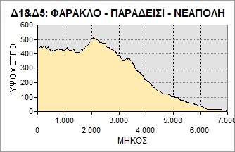
| Length (m) | 3,521 | |
| Terrain (m) | Path | 1,338 |
| Unsurfaced road | 688 | |
| Surfaced road | 1,495 | |
| Altitude (m) | start | 345 |
| finish | 2 | |
| Altitude (m) | lowest | 2 |
| highest | 345 | |
| Slope (average %) | ||
| Overall direction | W | |
| Difficulty | 2 (1-5)  |
|
| Signposts | FEW | |
| Beauty | 4 (1-5) |
|
| Drinking water | YES | |
| Vegatation | 4 (1-5) |
|
| Display the route via Google Earth |
||
 |
||