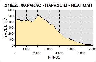
D1: FARAKLO – PARADISI
View larger map
These two routes (D1 &D5), on the old network of trails throughout the Maleas peninsula, can be combined. Start out at the main church in Faraklo, the village that used to be the Vatika region’s administrative centre. Follow a narrow surfaced path through to the east of the village, passing below the old school, for about 330m, to the beginning of the path to Paradisi. The path rises up a gentle slope to the southeast, with a marvellous view over the plain beyond Neapoli and across to the island of Elafonisos.
After 1,710m the path emerges onto the main road leading to Kastania. Head down the road in the direction of Neapoli. After 760 m a path branches off the road to bypass the switchbacks. After about 200 m the path emerges onto the road again and after another 405 m takes you to the church of the Virgin (Panayia) in Paradisi, once the most important settlement in the region due to the abundant watermills along the stream bed that descends the steep gorge below the church.
| Category | Mountain trek | |
| Route | Trek | |
| Length (m) | 3,401 | |
| Terrain (m) | Path | 1,903 |
| Unsurfaced road | – | |
| Surfaced road | 1,498 | |
| Altitude (m) | start | 430 |
| finish | 345 | |
| Altitude (m) | lowest | 345 |
| highest | 510 | |
| Slope (average %) | ||
| Overall direction | SE then SW | |
| Difficulty | 3 (1-5)  |
|
| Signposts | YES | |
| Beauty | 4 (1-5) |
|
| Drinking water | YES | |
| Vegatation | 3 (1-5) |
|
| Display the route via Google Earth |
||
  |
||